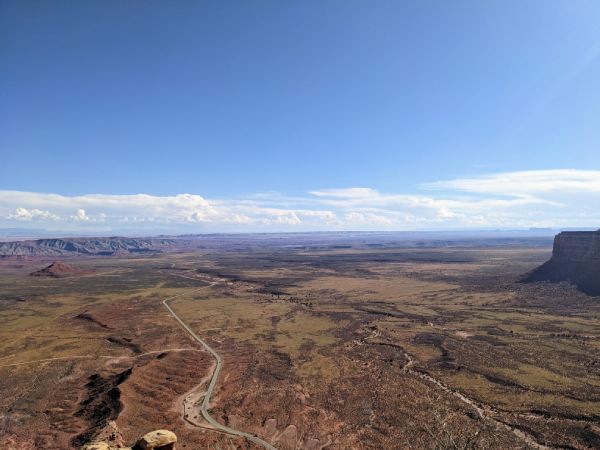
From the National Monument, I drove about an hour south on the state highway to Moki’s Dugway. It’s a steep section of road that gets you from where you are on the plateau down into the valley.
All the signs on the road in were hyping this thing up. No RVs or trucks allowed. Steep grades and sharp turns. I figured it was going to be difficult to navigate. To be honest, I was a little nervous. But it was just a normal dirt road that slowly meandered down the cliffside. Really beautiful views from the top.
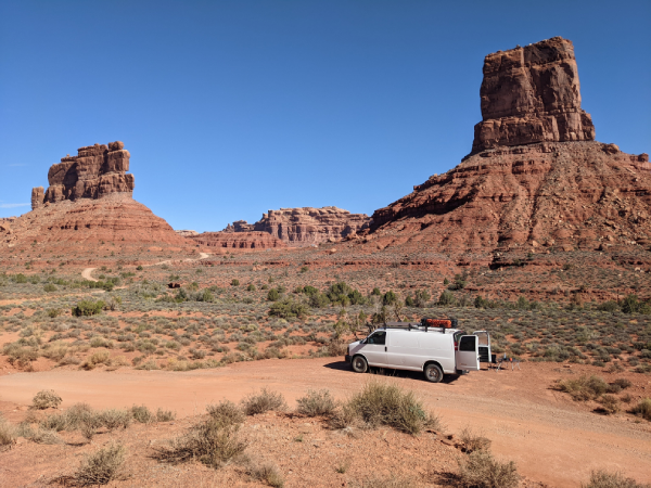
I was close to the Valley of the Gods at this point. The area is BLM which means free camping. My plan was to drive and find a campsite and then drive out the next day and make my way to Mexican Hat.
The road was a lot rougher than I was imagining it was going to be. Some deep ruts and holes in the road to navigate. I was worried about some of the cars behind me with low clearance. It must have been affected by the flash flooding that affected the national monument trail.
The drive in is beautiful but pretty standard for Utah. It’s not until you get to the 8-mile mark that you understand why this is the place to be. Two giant buttes dominate the terrain here. The road meanders back the way it came and you can drive between the two structures.
I was able to find a campsite right near Castle Butte which was the geologic feature I liked the best. I was able to sit there all day and take in the view. When you imagine the desert in Utah this is what you see. When you look closely you can see the exact places in the rock where the water would work its magic over time. It was very cool to take in.
I had a lazy morning and then drove down to Mexican Hat in the early afternoon. Not much going on in the town itself. There is a small rock formation that, admittedly, looks like a head with a large sombrero on. Hence the name of the “town”.
I originally intended on going down to Monument Valley which is south of Mexican Hat on the Navajo reservation. About an hour and a half away. But I decided against it. I will come back and pay it a visit. I was done with desert buttes for the time being.
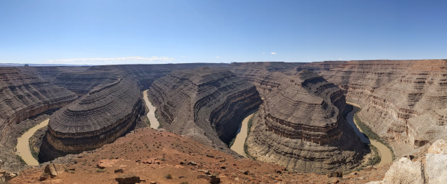
Instead, I went to Goosenecks State Park just outside of the town. It’s a view of a double horseshoe bend created by the San Juan River. You pay 5 dollars and you get to take in the view. I set up the grill and made lunch.
The sign said that this area is one of the best examples of a meandering river in the world and I believe it. A good spot to set up the grill and make lunch.
There was only one picnic table with shade and the sun was very strong. I sat down to eat at the same time a bus full of tourists parked up. They sat with me and I was integrated into the group for a short while. They were from Spain and most of them could not speak English.
I was able to communicate with them and get my story across. To a few of them at least. My ability to communicate in Spanish still exists but there is room for improvement. I want to spend some time getting back into it. Reading and listening are activities I should be doing a few times a week.